Google Earth is a powerful and free Google tool that we can use for family tree research and genealogy. In this post, learn how to put it to work to help you learn more about your ancestors and share your research with others.
The internet is filled with free tools that we can use for learning more about our family tree, even if they weren't necessarily designed as a genealogy research tool. Google Earth is one of many such tools.

The easiest version of Google Earth to access is the "browser version", which can be run in most browsers that you use to access the internet. There are also Google Earth apps that you can download to your iPhone or Android phone, and some of the ideas in this post can be done this way.
Some of the recommendations included below require the Google Earth Pro desktop version. This can be downloaded for free on the Google Earth site and can be run on most desktop or laptop computers.
So, let's get started exploring ideas about how to use genealogy on Google Earth, shall we? I use it almost every day, and I hope you find it as helpful as I do!
Find an address where your ancestors lived using google earth
It is fun and interesting to look up the places where your ancestors lived in Google Earth. You can learn about the general characteristics of their community, and potentially even see the actual structure where they lived during their lives.
Many locations on Google Earth, including places around the world, allow you to explore the streets and roads as if you were walking or driving there. You can take a little virtual trip around the towns where your ancestors lived and envision what life may have been like for them.
Some buildings, especially those that are now open to the public as historic places, have photographs that you can explore on Google Earth.
It's easy to look up an address on Google Earth. From within the Google Earth site, click the magnifying glass, type in the address you would like to view, and press enter to "travel" to that location.
Create a family tree migration map
This is one of my favorite ideas for using Google Earth for family tree research, even though it's not really "research". Instead, it's a fantastic way to share everything that you have learned with your family.
If you have ever tried to explain your family tree to relatives, you might have found yourself stumbling over exactly where to start. It's also hard to include everything that you want to tell your family in just a few sentences.
Sometimes, a few sentences are all we get a chance to say before our family members start to become confused and give up trying to understand. This is where Google Earth can be of help, especially for those relatives who love technology, maps, or have a visual style of learning.
There are a few different ways that you can implement a family tree migration map on Google Earth. The ideas that I list here will primarily be useful on the browser version (i.e. internet version) of Google Earth.
Create a project with important locations from the family tree
You can create a project that includes locations all over the world where your ancestors lived, which is great for those of us who had ancestors who traveled a great distance from where we live today. Making a project on Google Earth is easy to do, and all you need to have is a Google account, such as one that you use for Gmail.
The map below is just a sample from one project that I have made that details my ancestors' lives in Slovakia, as well as their life in the United States. My plan is to add their children and grandchildren to the map so that way I can share this project with their living descendants and they can see how their family ended up living where they live now.

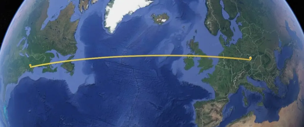
The details that you could include on such a map could include almost unlimited detail. You could add specific addresses, if you know them, and even include photographs of your relatives, their homes, or the places where they worked.
All you need to do to create a project like this is click the "New Project" tab from the main dashboard and add your locations and details. To share your project, simply click the little person icon that has a plus next to it (located above the name of you project) and enter the Google e-mail address of the person you would like to share the project with.
If there is enough interest, I can create a tutorial for exactly how to go about making a map like this on Google Earth. It is a lot more in-depth than some of the simpler ways to share your research (such as a family history timeline created in Word), but much more powerful and interactive.
Plot locations of events in your family tree in a project
Similar to the idea above, you can use Google Earth to create a comprehensive map of locations that are important in your family tree. If your family has a long history in the same part of the country, this is an especially interesting idea, since many of your relatives might not know how important the local areas are to your family history.
This idea includes the use of the "Project" capability on the browser version of Google Earth. It does require you to have a Google account (you can get one for free) and be logged in.
Sharing the project is simple once you are done. You can even invite other relatives who are interested in helping to join in the effort to create a comprehensive family map on the project.
You could plot all of the regional locations of your ancestors, their children, and grandchildren. If you have the address of the place where they lived, worked, attended church or school, those spots could be included in the project, too.
On my projects, I never include details about living relatives. You can examine your privacy settings on your project, as well as the sharing settings, in order to decide whether you would like to exclude information about living family members from your projects.
Examine cemeteries and even gravestones
You can travel through cemeteries and potentially even read inscriptions on gravestones and memorials from Google Earth.
Recently, my son and I were exploring Google Earth and noticed a cemetery. I was surprised at the detail visible of many of the gravestones and memorials that could be seen from photographs taken from the roads through the property.
This led me to explore some cemeteries where I have ancestors buried, and I realized that both the browser (i.e. internet) version of Google Earth, as well as the desktop version, allows for you to explore many cemeteries. In some cases, you will be able to even see the writing on certain stones.
Of course, this won't be the case for many stones. However, it is certainly worth checking to see what is visible on cemeteries that have an importance to your research.
The Google Earth Pro version that you can download to your computer has more detailed imagery than what is available online. You can do "Street View" (called "Ground Level View" on the software) just like on the browser version, and when there is no street view available, satellite images come together to make a substitute.
This means that you can "walk" through the cemetery using satellite images. If you have additional information, such as maps, available to help you find a relative's burial location, you can use Google Earth to plan your visit to the cemetery.
For example, the images might help you understand the condition of the gravestones, the terrain of the cemetery, as well as help you decide exactly where to check first during your visit.
If you don't yet know where your ancestors were buried, you can do a bit of searching on Find-a-Grave, or see if you can locate an online obituary.
Measure distances between locations your ancestors frequented
One of the easiest ways to use Google Earth is to measure distances between locations where your ancestors lived, or possibly lived, and other places you know that they frequented. This can help you learn more about your ancestor by understanding how a typical day in their life may have looked.
I use this feature of Google Earth frequently, especially when I am deciding whether a genealogy record belonging to someone with the same name as my ancestor truly belonged to my ancestor. By calculating the distance between the location of the record and other known places they frequented, I can decide how likely it is that the record is truly theirs.
Examine the terrain your ancestors traveled
While our ancestors did certainly travel more than we imagine, they did so without the transportation technology that we have today. We can learn quite a bit about their lives, as well as the history and culture of their community by studying the terrain or topography of where they lived.
One important item that you will see are natural features, such as hills and mountains, which are not always very obvious on the regular Google Maps or maps used for navigation purposes. In addition, you can also easily see the elevation of a particular location on Google Earth, which makes it easy to understand the types of challenges your ancestors may have faced on a daily basis.
The Google Earth Pro version that you download to use on your computer has more detailed 3-D images that allow you to better understand the terrain.
Overlay old maps into Google Earth
You can overlap images of old maps into modern Google Earth satellite images in order to identify where streets, buildings, and other locations that no longer exist would be found today. This can help you find new clues about where to look for more documentation about your ancestors.
We can sometimes even see natural features, such as hills or islands in the middle of a river, that our ancestors may have encountered that are no longer there. Humans are quite adept at modifying landscapes, as I am sure you are aware, so there might be many old features are no more.
As we know, old maps are a very useful tool for genealogy. My Slovak ancestors who lived in Holyoke, Massachusetts lived in a tenement-type building that was owned by the company where my great-great grandfather worked.
The company, the mill, the building, and even the street where it was located, no longer exist in any recognizable form. At least, to someone like me who is not an expert in maps and who has never been to Holyoke, MA.
However, by overlaying an old map that I found on a government archive website into Google Maps, I was able to identify the precise location of where I would need to visit today to see where my great-great grandparents lived. Without this tool, too much is left to guesswork.
In the map below, I circled "Park St" in red because it is a little bit hard to see with how I have the transparency of the map set. I wanted to know if there is a current road at the same location, and so I needed to be sure to have the transparency of the image set low so I could read the modern street names.

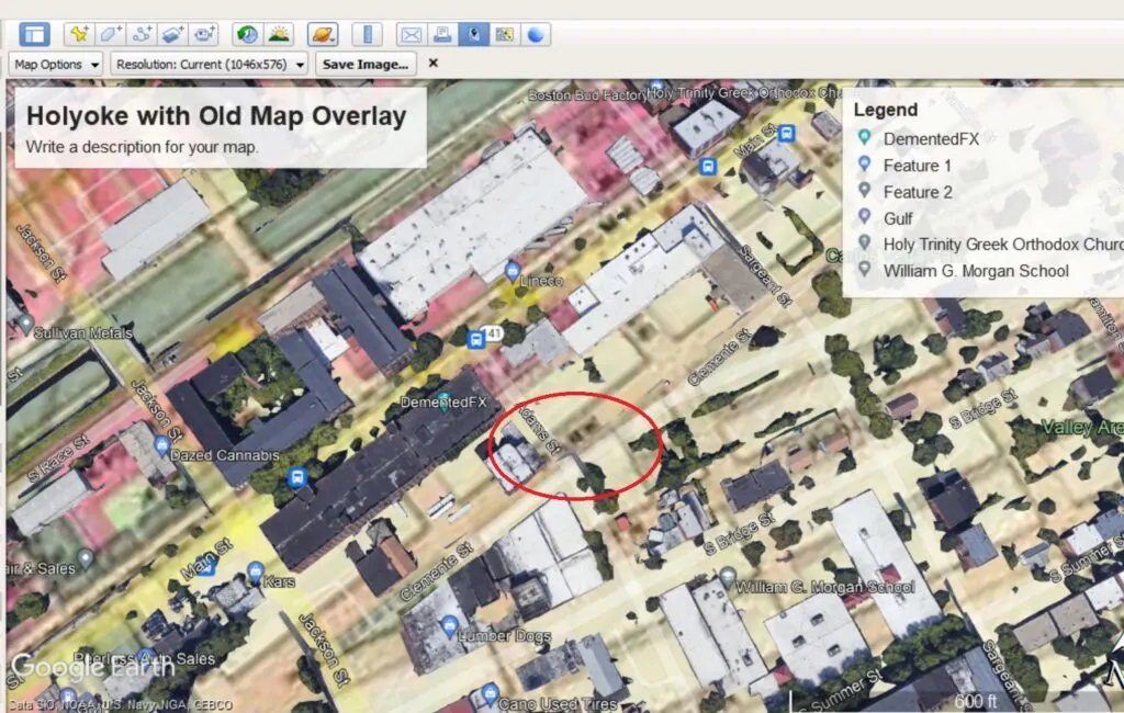
I am not 100% positive, but I believe that the place where my ancestor lived at one point was a bit to the left of where the red circle is, where you can now see faint outlines of maybe trailed for storage. In any case, it seems like it is a vacant lot now.
The only way to overlay maps into Google Earth is by downloading and installing the desktop version to your computer using the links that I included towards the beginning of this article. It can be a little tricky to get your map aligned correctly, but some tips include:
- Starting off with your view of the modern map on Google Earth to be the same general elevation as the map that you want to overlay
- Using the green diamond and green corners to rotate and resize the image to fit the modern map
- Don't press "OK" until you are satisfied with the overlay, otherwise, you will have to import it again
Depending on the quality of the old map, as well as your patience and skill with the mouse, you can probably get a very good overlay that can provide a great deal of information to you. I found this video helpful to learn how to adjust the image to the right spot.
Conclusion
I hope that this post has helped you understand all of the different ways that Google Earth can help you learn more about your family tree and share your work with others. It really is a great educational tool that is fun to use, too.
If you have any questions about something that you read in this post, or if you would like to share something exciting that you discovered about your ancestors using Google Earth, please join us in the discussion below.
Thanks for stopping by and reading today.
Clay Price
Sunday 13th of February 2022
Thanks for another great article, Mercedes! I used Google Earth for years in helping churches see where their members lived. And it was great to look for the locations of rural churches that did not have exact addresses. Numerous other applications as well. But I never made the connection to my ancestry research! Now you've given me another aspect to tackle. Thanks much. Clay Price